| LiDAR | ||
Airborne lidar technology is widely accepted among power utility companies as the most efficient tool for acquiring high-density and high-accuracy geo-referenced spatial data for various applications essential to power line asset management. |

LiDAR (Light Detection and Ranging) mapping is the process of scanning surface features of the Earth with laser pulses to create 3-dimensional models of the spatial environment. These light pulses—combined with other data recorded by the airborne system— generate highly accurate, precise, three-dimensional information about the shape of the terrain underneath and its surface characteristics. |


The resulting georeferenced point cloud data can be used to generate a wide variety of other geospatial products. Skytek employs advanced methods to create highly accurate, intelligent data for entire transmission corridors, providing detailed power line and infrastructure information such as line sag, crossing violations, vegetation clearances and encroachments. Our systems are designed to meet the precision survey requirements of electrical utilities providing the capability to acquire high-resolution LiDAR data, Ortho-images and oblique images of every inch of a power-line corridor. |

Utilizing the latest data acquisition technology, Skytek provides clients with a highly detailed and spatially precise three-dimensional snapshot of the existing conditions within their transmission line corridor, allowing for accurate and efficient corridor management. |

Our team has substantial experience in planning and accomplishing missions to produce innovative and high quality geo-information products specially adapted to the customers’ needs. We carefully consider technology choices and survey design to optimize data quality. Our services include remote sensing, GIS, processing, spatial analysis and spatial modeling. |


VISUALIZATION |
||
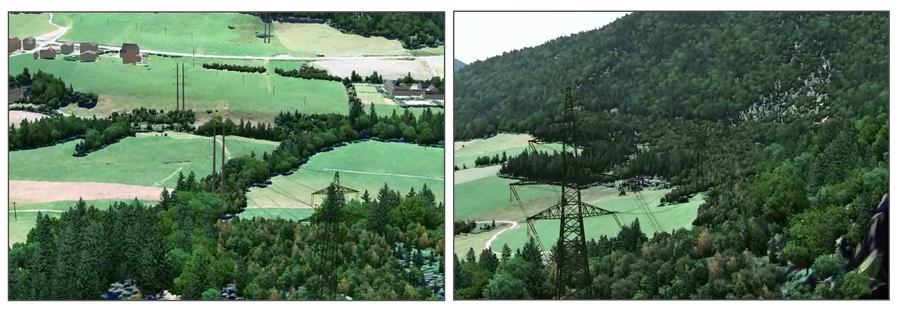
| When siting a transmission line, electric utilities must consider many factors, including protecting the natural environment, engineering challenges, cost efficiency, government regulations and especially effects on and reactions of the community. This can be particularly problematic as local communities often try to stop construction, relocate it or maybe even prevent it altogether, thus causing large increases in costs. It is a natural response but it can be reduced. Based on technical documentation, combined with LIDAR and photographic data, we can produce detailed 3D simulations - animations and previews from selected viewpoints of how the new power-line will impact the environment. How many trees will have to be cut down, how visible will it be, how would it look if the pylons were painted dark green as opposed to grey. We can quickly produce multiple variants that can be displayed to the community, possibly swinging public opinion. |